By
Mobolaji Aluko
January 5, 2004
Introduction
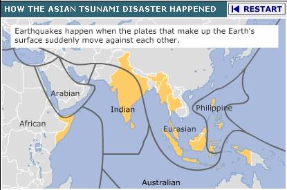
On Boxing Day December 26, 2004, the world awoke to a horrific news: a tsunami had “boxed” out whole towns and villages in and around islands in the Indian Ocean/Pacific Ocean of South-East Asia (from Indonesia to India to Thailand), and extended its grievous reach to the Horn of Africa (Somalia). The death toll is still rising – and at last count as many as 150,000 human beings – not to talk of fauna and flora – are missing and/or presumed dead.

How could this devastation have occurred?
Well, let us look at some back-of-the-envelope arithmetics of the physics of the Tsunami.
![]() Tsu-nami
(Japanese for “harbor-wave”)
Tsu-nami
(Japanese for “harbor-wave”)
Some speeds to consider
In normal stride, an adult walks roughly at the speed of 5
kilometers per hour (km/h) or 3.1 miles per hour (mph). A person who runs 100
meters in 9 seconds runs at 40 km/h - or roughly 25 mph [1
mph = 1.60934 km/h;
1 km/h =0.621371 mph.].
Above 55 mph (or 88 km/h), you will get a speeding ticket
driving in most highways in the
The Tsunami and Channel Flow
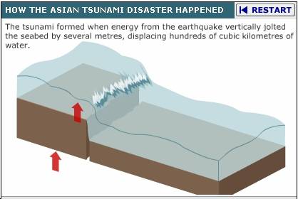
Think of a long rectangular container filled with water, tilted such that water can flow out from one end. For a tsunami here, the water is ocean water; the bottom of the container is the ocean floor - and the sudden tilt of the container is caused by an earthquake. In the case in question, it was a megathrust earthquake of moment magnitude 9.0 on the Richter scale.

And that water flows onto coastal land and beyond (as far as 1 km or 0.6 miles inland) – into where human beings live.
The Speed of the Tsunami
So what was the speed of the Tsunami that hit parts of
It depends on where in the ocean the quake which started the channel flow of water began, causing a shallow-water wave. Multiply the ocean depth (in meters) by roughly 10 (actually 9.8 meter per second squared), square root the product, multiply it by 3.6 – and you get roughly its speed in km/h [ see Table 1 below.]
We are told that the SE-Asia tsunami moved up at speeds up to 800 km/h – which means that it must have come from depths of about
5,000 m (5 km). [Average depth of the
Of Tornadoes and Hurricanes
The speed of the water when it got to land is much slower – but you get the idea that it could be sufficiently fast to sweep objects in its path away. Even equally devastating is the HEIGHT of the water when it hits land, drowning life.
I have also given in Table 2 the equivalent wind speeds and
categories for the more familiar depressions, storms,
tornadoes and hurricanes. In
August/September 2004, the mid-Atlantic/Southeast states (particularly the state
of Florida) witnessed five major land-falling hurricanes:
Hurricane Charley ( around August 13) was 145 mph [233 km/h;
Level 4] and Gaston (at 75 mph, a Level 1 Hurricane in August; reclassified as a
hurricane after the season), and the rest in September were
Frances (around September 5; 105 mph; 169 km/h; Level
2), Ivan (around September 16; at 200 km/h, a Level 3 Hurricane) while Hurricane
Jeanne was about 75 mph (120 km/h a Level 1 Hurricane; around September 26).
Only Gaston missed
Noting that the density of sea water is about 1,030 kg / cubic meter while that of dry air is 1.2 kg per cubic meter at room temperature – and with kinetic energy directly proportional to mass and to the square of the moving medium’s speed - one can see that water of the same speed as air packs about 1000 times more energy ! [Doubling the speed (for example) quadruples the kinetic energy.]
Lord have mercy !
So Please Donate
Now that you have a rough idea of how devastating a tsunami is –
and why it wrought what it did in
May God rest the soul of those who died, and may God bless the lives of those who donate. [Amen.]
Mr. Wilson Iguade
[Nigeria/Naijapolitics Tsunami Donation Contact Person]
P.O
Cell: 469/569-3595
American Red Cross International Response Fund
800 HELP-NOW
See also: International Red Cross and Red Crescent Societies (www.ifrc.org)
Action Against Hunger
247
212 967 7800
Doctors Without Borders/Medecins Sans Frontiers
Merrifield
VA 22116-8056
888 392 0392
http://www.doctorswithout-borders.org
World Vision
P. O. Box 9716
Dept W
Federal
888 511 6592
The
Catholic Relief Services (800-736-3467)
Bibliography
http://news.bbc.co.uk/1/hi/world/asia-pacific/4136289.stm
Taken from “Animated Guide: The Tsunami disaster”
http://en.wikipedia.org/wiki/Density_of_air
Density of Air
http://hypertextbook.com/facts/2002/EdwardLaValley.shtml
Density of Sea Water
http://www.geophys.washington.edu/tsunami/general/physics/meaning.html
What Does “Tsunami” mean ?
http://www.news-journalonline.com/NewsJournalOnline/News/Neighbors/DailyJournal/03AreaDJ02123004.htm
Hurricanes top news story
Table 1: Relationship of Tsunami Water Speeds to Ocean Depth
|
Ocean Depth meters |
Tsunami Speeds Km/h |
Tsunami Speeds mph |
Comment on Ocean Depth |
|
10 |
36 |
22 |
|
|
100 |
114 |
71 |
|
|
150 |
139 |
86 |
|
|
200 |
161 |
100 |
Off the |
|
300 |
197 |
122 |
|
|
400 |
228 |
142 |
|
|
500 |
255 |
158 |
|
|
1,000 |
360 |
224 |
|
|
1,038 |
367 |
228 |
Average depth of |
|
2,000 |
509 |
316 |
|
|
3,000 |
624 |
388 |
|
|
3,872 |
708 |
440 |
Average depth of |
|
4,000 |
720 |
447 |
average overall depth of oceans |
|
4,188 |
737 |
458 |
Average depth of |
|
5,000 |
805 |
500 |
|
|
5,450 |
840 |
522 |
|
|
7,000 |
952 |
591 |
|
|
7,725 |
1,000 |
621 |
Java Trench – deepest
in |
|
8,000 |
1,018 |
632 |
|
|
8,648 |
1,059 |
658 |
Puerto Rico Trench –
deepest in |
|
10,000 |
1,140 |
708 |
|
|
11,000 |
1,194 |
741 |
|
|
11,033 |
1,196 |
743 |
Mariana Trench –
deepest in |
|
12,000 |
1,247 |
774 |
Just above the speed of sound (~ 1200 km/h) |
Source: http://mbgnet.mobot.org/salt/oceans/data.htm
Table 2: Classifying Depressions, Storms, Hurricanes and Tornadoes
|
Category |
Damage |
Wind Speeds mph |
Wind Speeds Km/h |
|
Tropical Depressions |
|
23-39 mph |
37-63 km/h |
|
Tropical Storms |
|
40-73 mph |
64-117 km/h |
|
Hurricanes (or Typhoons)* |
|||
|
Saffir/Simpson Scale Category |
Damage |
Wind Speeds mph |
Wind Speeds Km/h |
|
Level 1 |
Minimal |
74-95 mph |
119-153 km/h |
|
Level 2 |
Moderate |
96-110 mph |
154-177 km/h |
|
Level 3 |
Extensive |
111-130 mph |
178-209 km/h |
|
Level 4 |
Extreme |
131-155 mph |
210-250 km/h |
|
Level 5 |
Catastrophic |
>155 mph |
>250 km/h |
|
|
|
|
|
|
Tornadoes |
|||
|
Fujita Intensity Scale Category |
Damage |
Wind mph |
Wind Km/h |
|
F0 |
Light |
40–72 mph |
64-116 km/h |
|
F1 |
Moderate |
73–112 mph |
117-180 km/h |
|
F2 |
Significant |
113–157 mph |
181-253 km/h |
|
F3 |
Severe |
158–206 mph |
254-331 km/h |
|
F4 |
Devastating |
207–260 mph |
333-418 km/h |
|
F5 |
Incredible |
261–318 mph |
420-512 km/h |
*The term hurricane is used for Northern Hemisphere tropical cyclones east of the International
Dateline to the
of the Equator west of the International Dateline.
Sources:
http://hypertextbook.com/facts/StephanieStern.shtml
http://www.infoplease.com/ipa/A0193170.html
http://www.ucar.edu/educ_outreach/webweather/hurricane2.html
http://www.hawaii.navy.mil/hurricane/hurr_info.htm
http://www.aoml.noaa.gov/general/lib/laescae.html
http://www.nhc.noaa.gov/aboutgloss.shtml